Improving the reliability of passenger and freight transport, across its different modes and uses, with effectively managed costs and externalities

Research of various types was conducted in 2019 to help design more reliable and resilient transportation systems. Initiatives to transfer knowledge from research to central government directorates have been undertaken to improve our understanding of the logistics and traffic management sector with a view to improving the availability of transport systems and reducing their operating costs.

Research was undertaken to support the upgrading of the rail system to improve its economic, functional and safety performance. A focus study is proposed on Channel Tunnel safety, a topic our Institute has been addressing since 1986.


In accordance with its remit from the DGITM (Directorate General for Infrastructure, Transport and the Sea) and the DGE (Directorate General for Firms), IFSTTAR has drawn up a preliminary dashboard for logistics and its performance. On 16 September 2019, the Prime Minister announced the creation of an Interministerial Logistics Commission to supervise this sector at a strategic level. In this connection, it is advisable to provide some sort of framework and draw lessons from the quantitative and qualitative data regularly produced by public administrations, professional organisations and scientific bodies.

In this context, the DGITM and the DGE have entrusted IFSTTAR with the task of evaluating the performance of the logistics sector. A dashboard has been developed, based on a set of key indicators relating to the economic, social, environmental and energy performance of the sector. Several criteria were used to select the indicators for this dashboard:

  • The reliability of the data and the frequency of its production, so the trends affecting the indicators can be monitored;
  • The comprehensibility of the dashboard, which means avoiding too many indicators;
  •  The dashboard should be helpful to both public and private stakeholders.

In addition to the development of this dashboard, the remit also includes the coordination of a logistics observation network, bringing together the stakeholders in the sector. The first meeting was held on 21 January 2020 at Université Gustave Eiffel. In 2020, Université Gustave Eiffelwill continue this work by producing summary documents for decision-makers.


Container stacking © Guillaume Uster - Ifsttar

Mixing data, expertise and approaches to provide better tools for traffic management and the dynamic modelling of travel

Sharing urban space better between modes, reducing congestion and pollution, increasing road safety... Optimising the use of existing transport infrastructure is a goal for every manager. This requires better tools, that are better used.  The Messigéo research initiative aimed to make better use of the large amount of data available and to develop effective tools to meet current transport challenges. It took advantage of the long-term partnership that has been built between the Centre d’Expertise sur les Risques, l’Environnement, la Mobilité et l’Aménagement (CEREMA) and IFSTTAR. This has permitted a fruitful exchange of ideas between the researchers at CEREMA, who work closely with public and private transport infrastructure managers, and those at IFSTTAR, who are able to propose new methods in this area, while also providing their knowledge of the international state of the art. Some findings are given below:

  • Dynamic modelling and evaluation of the traffic control strategies deployed on peri-urban motorways, in some cases with a degree of connectivity between certain vehicles and the infrastructure. We now offer solutions that overcome two shortcomings of the existing technologies as they provide shorter computation times and the ability to accurately reproduce the effects of control measures;
  • Optimum route planning, covering all the possible modes: walking; cycling (including shared bikes); urban or interurban public transport, track-guided or not; cars, shared or not. This inclusion of all modes means accessibility can be approached in a genuinely multimodal way;
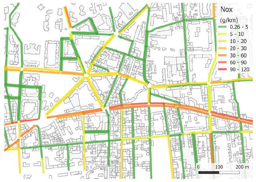
  • Joint analysis of data on pollution and traffic and a multi-scalar traffic-emission modelling chain. This means we have instruments that highlight the effect of speed and the proportion of heavy goods vehicles on oxides of nitrogen (NOx).
Map of traffic-related emissions, at segment level © Traps, CEREMA,LICIT, D. Lejri, A. Burianne

Channel Tunnel safety

For INRETS (French National Institute for Transport and Safety Research) then for IFSTTAR, Gérard Couvreur, former deputy director of IFSTTAR's Villeneuve-d'Ascq centre, has been following the Channel Tunnel since its inception, helping to make the operation of this unique transport system safe and efficient. His retirement will mark the end of this involvement for the new Université Gustave Eiffel. This last IFSTTAR activity report provides an opportunity to review the main features of this work.

Since 1986, when the Treaty of Canterbury and the quadripartite concession agreement were signed, the "Cross-Channel Fixed Link" has been supervised by the Intergovernmental Commission (IGC) appointed by the French and British governments to monitor its construction and operation.

One of the IGC's areas of competence is safety, for which the Treaty set up a Safety Committee. During the construction phase, this committee examined the 23 "Preliminary Projects", each dealing with a specific technical subsystem (rolling stock, signalling, railways, ventilation, power supply, etc.) as well as engineering structures and buildings (terminals, civil engineering works, etc.). In 1994, this work enabled the fixed link to be brought into commercial operation.

In spite of a few incidents, some of which, notably the fires of 1996 and 2008, had significant material consequences the initial safety concepts have proven to be robust. No fatalities or serious injuries have occurred.

Twenty-five years after its commissioning, the Channel Tunnel is reaching a period in its life cycle where the obsolescence of its systems needs to be addressed. For example, the time for the mid-life overhaul of the shuttles, which is required for all rolling stock, has come. The highly unusual nature of these trains makes this operation both complex and sensitive. In addition, the TVM 430 Track-to-train transmission system will soon be replaced by the ERTMS (European Rail Traffic Management System), a rail signalling system which, in theory, will ensure interoperability across all European networks.


The entrance to the Channel Tunnel © EuroTunnel

MORIPAN (Models of Risk for Level Crossings)

MORIPAN is a project supported by theRaileneum IRT, with the involvement of ESTAS (Evaluation of Automated Transport Systems and their Safety Laboratory) in the COSYS department and SNCF Réseau. Its aim is to develop risk models in order to identify and describe safety issues on level crossings, which is a subject of government concern, and take action to deal with them.

The MORIPAN project aims to identify the main risk factors, assess their respective contributions in order to guide safety improvements at level crossings and allocate resources efficiently.

An in-depth statistical analysis of accidents in France has highlighted three main road-related causes: driver inattention, the inability to clear level crossings quickly enough, and a serious offence resulting from careless behaviour.

An experimental phase made it possible to observe the behaviour of road users at 12 level crossings over a period of 3 months. Bayesian network models were then developed. These revealed and described the causal relationships between the various factors, risk scenarios and the occurrence of accidents.

This type of mathematical model allows us to quantify how each of the identified factors contributes to the overall level of risk. It can provide a basis for forecasting how different solutions could improve level crossing safety. This detailed knowledge will enable the infrastructure manager and other stakeholders to efficiently allocate available resources to improve level crossing safety.

The results obtained within the framework of MORIPAN were presented at a transfer seminar organised in the framework of the parliamentary commission on level crossing safety, coordinated by the deputy Mme Laurence Gayte.The results obtained within the framework of MORIPAN were presented at a transfer seminar organised in the framework of the parliamentary commission on level crossing safety, coordinated by the deputy Mme Laurence Gayte.

An urban level crossing © Mohamed Ghazel - Ifsttar

ERSAT-GGC (ERTMS on Satellite Galileo Game Changer)

ERSAT-GGC is a European H2020 project whose goal is to speed up the certification process for a positioning system based on satellite technology (GNSS) to be used on regional railway lines equipped with the European Rail Traffic Management System (ERTMS).

In the European ERTMS/ETCS railway standard, the absolute position of a train is ascertained when it passes a trackside beacon. Between beacons, the position of the train is calculated by odometry. For level 3 ETCS (European Train Control System), the position of the train should be computed on board the train. The use of GNSS is now recognised as a good way of replacing the trackside equipment with virtual beacons. However, the performance of the technologies depends on that of GNSS, which is itself affected by multipaths, signal attenuation or obstruction by obstacles near the train.

With RFI in the leadership role, ERSAT-GGC has contributed to the development of a methodology and tools that classify lines according to the anticipated performance of the satellite system. This classification is based on a series of tests aimed at detecting masking, multipaths and interference based on measurements collected by on-board COTS (Component On The Shelf) equipment and the analysis of parameters such as CN0, pseudo-distances, AGC, images, etc. These tests are used to identify the areas where the virtual beacons can be deployed. The procedures and tools thus developed have been tested and evaluated on several railway lines in Italy and Spain. An analysis of the operational security of the technological architecture was also carried out as part of the project.

Equipment (PREDISSAT) developed by IFSTTAR and installed on a train for a campaign to detect the reception of indirect GNSS signals © Juliette Marais - Ifsttar