Reference
Foreseeing natural and climate risks
Two focuses have been chosen to illustrate this objective. They relate to the transfer themes in the COP 2017-2021 with, on the one hand, the forecasting of floods and the associated risks to infrastructures (7.1) and, on the other hand, seismic risk and ground movements (7.2).
ANR SSHEAR project
Scouring processes are a major cause of the destruction of constructions (engineering structures, earthworks and buildings), especially during major floods, but the way they are addressed is still too empirical. The SSHEAR project has improved our understanding of scouring mechanisms and led to the development of innovative observation and modelling tools at the scales of both experimental models and real structures with a view to proposing optimised methods for diagnosis, warning and management. This project has also made it possible to acquire scientific and technical expertise that was almost non-existent in France, but also international expertise focused on issues that differ from those affecting France. The team managing the SSHEAR project had to create the conditions for this national expertise to emerge. In order to enhance our knowledge and propose optimised methods for diagnosis, warning and management, the SSHEAR project was based on a multi-scale multidisciplinary approach. This focused on: - the physical processes of flow and erosion in the vicinity of structures (bridges, banks, etc.); - three laboratory experiments offering multi-scale observation; - a truly innovative approach to two-phase modelling; - field observations and measurements as well as the development of equipment. A one-day feedback meeting to present the main results of this project was held at IFSTTAR on September 11, 2019 and brought together more than 70 researchers.
Instrumentation of engineering structures to identify the risk of scouring by vibration analysis
In the framework of this project, the thesis "Vulnerability of engineering structures to the risk of scouring" by N. Boujia (2018), dealt with the instrumentation of engineering structures to identify the risk of scouring by vibration analysis. Two avenues were explored: direct monitoring of the behaviour of bridge piers and a feasibility study for a scour sensor. The dynamic behaviour of the piles was studied by modelling, validated by hydraulic channel experiments at the LHSV (Saint-Venant Hydraulics Laboratory) in Chatou and the instrumentation of a bridge on the A71 motorway. This work is currently continuing with inverse modelling and identification of scouring in the context of M. Belmokhtar's doctoral research.
Seismic response of soils and the phenomenon of liquefaction
Transfer theme 7.2 deals with seismic risk and ground movements through findings on soil liquefaction and the in-situ characterisation of this phenomenon.
Recent changes in earthquake-proofing regulations in France (Decrees n°2010-1254 and n°2010-1255 of 22 October 2010) mean a reassessment of the seismic risk is required for a very large number of structures. At the research level, major advances have been made in understanding the phenomena linked to severe earthquakes, particularly since the exceptional Tohoku event (Japan, 2011). The seismic response of soils and the phenomenon of liquefaction explain the devastating effects leading to the loss of bearing capacity in the foundation soils, large-scale flow slides, the collapse of structures and significant damage to urban networks (e.g. Port of Nice, 1979; Tohoku, 2011). However, there is still a need to improve the understanding and modelling of these phenomena on the basis of appropriate tests at the scale of the material (laboratory behaviour tests) and at the scale of the foundation soil (physical modelling). IFSTTAR has proposed to develop advanced experimental devices in each of these fields, the objective being to better characterise the non-linear seismic response of soils (including liquefaction) and the dynamic soil-foundation soil-structure interaction in the laboratory at different scales, and thus to limit damage to urban structures and networks. Since seismic action is characterised by the appearance of shear stresses alternately and repeatedly at different frequencies and amplitudes, the rotations of the imposed stresses can only be simulated in experimental devices allowing the application of cyclic simple shear deformation up to several hertz. A platform containing complementary devices capable of observing these phenomena from the intermediate scale of the material to that of the structure has been set up. Thus, the soil tested under a full-scale model structure in the largest case, can be tested at the scale of the soil-structure interface in the intermediate size material and at the scale of its representative elementary volume in the laboratory test.
To meet these objectives, regular financial support from the DGPR at the MTES has been put in place over the last three years to move these actions forward with funding that is earmarked to support ongoing doctoral research and the preparation of methodological documents. The ANR ISOLATE project as well as the CSR EGIDE project have also contributed and profited from this transfer theme dedicated to the understanding of soil liquefaction.
FUI DIDRO project
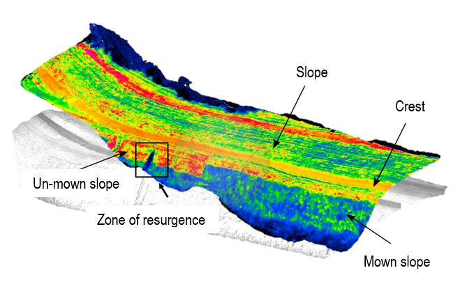
The DIDRO FUI project explored the various possibilities offered by drones for the surveillance of dikes: preventive surveillance and surveillance during floods.
As the French dyke system is generally in an unsatisfactory condition, new regulations have been introduced (Decree n°2007-1735) in order to bolster not only its management but also its effectiveness and safety. Faced with these new requirements, dike managers lacked any means of carrying out high-speed monitoring at an affordable cost.
The DIDRO project "Monitoring dikes with Drones" (2015-2019, an FUI project approved by the SAFE Cluster and ASTech competitiveness clusters) was thus set up, bringing together the companies Geomatys (the project leader), SURVEY Copter, Atechsys Engineering, the public establishments IFSTTAR, IRSTEA, CEREMA, IGN, Entente Valabre CEREN, DREAL Centre, together with the subcontractors L'avion Jaune and CEEMA and dyke managers, represented in particular by France Digues. The aim of the project was to develop an operational solution based on instrumented drones to support surveillance and reconnaissance missions for all types of dykes. The observation instruments - remote sensing cameras and sensors (operating in the visible, near infrared, thermal infrared domains, and LiDAR), aquatic measurement tools and ground-based geophysical methods - provide a set of data which, when used alone or in combination, make it possible to detect disorders that are visible on the surface of structures, but also to obtain information on some of their internal characteristics. The drone-borne technology is able to carry out high-speed data acquisition, both in the context of so-called routine surveillance missions and surveillance during hydro-meteorological crisis situations. The project has made it possible to bring several innovative technological bricks to maturity, then to integrate and validate them. Various restitution phases and a demonstrator were deployed to present the solution to end users (managers), financiers and SAFE Cluster. In addition to the numerous technical deliverables, a methodological guide was produced and the partners also looked into the economic model for operating the future "DIDRO" service proposed to dike managers.